 Landslides involve the downwards movement of soil, rock or debris when the stability of a slope is compromised. They range from small, slow slips to sudden, destructive collapses, particularly in steep or highly weathered terrain.
Landslides are often associated with other hazards, such as tropical cyclones and east coast lows that bring prolonged, widespread heavy rainfall and gale force winds.
They can have natural causes such as undercutting of cliffs and banks by waves or rivers, or saturation from rainfall or seepage. They can also be caused by human activity including removal of vegetation, drainage and landscape changes, and other activities.
Recent event: 2022 Floods
- Extreme rain triggered up to 300 landslides across the region
- Hillslides slumped, roads were cut off, forested areas collapsed
- Over $500m in road repairs*
- Some communities were isolated for up to 6 weeks
*Insurance Council of Australia
Landslide susceptibility
The mass movement map below identifies areas where limitations to land use have been put in place due to the susceptibility of the area to landslides.
The areas in orange (mass movement scores of 6-8) have a high risk of potential landslides.
Mass movement map
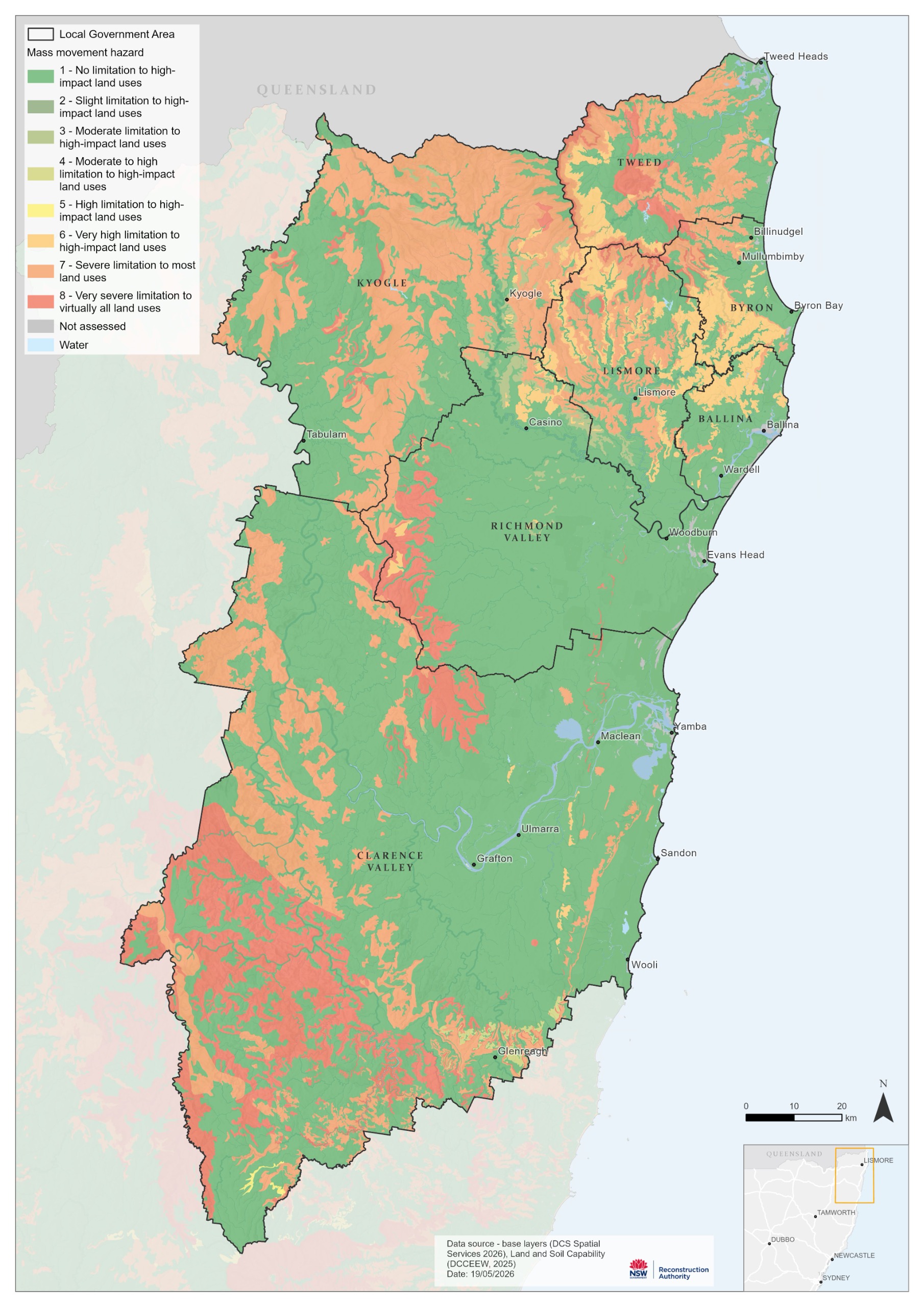
Source: Department of Planning, Industry and Environment / NSW Reconstruction Authority 2026
Current risk
Landslide susceptibility is based on slope angle, geology, rainfall and soil type. The areas in the Northern Rivers with the highest susceptibility (i.e. mass movement scores of 6-8) are around the Tweed caldera and along the foothills and ranges of the Great Dividing Range.
Future risk
With limited data on the true extent, scale and frequency of landslides it is not possible at this stage to confidently determine risk levels in the Northern Rivers.
Future work will include identifying:
- what data and historical records currently exist, their validity and accuracy
- what data or geotechnical analysis is needed to help identify risks and support decision making
Impacts
|
|
Built
|
|
|
Social
|
|
|
Economic
|
|
|
Natural
|
Next steps
Note: The information contained on these Have Your Say website pages is general information only, based on knowledge and understanding at the time of publication (June 2026) or otherwise based on data which pre-dates its publication, and may be subject to change at any time without notice. The State of NSW and its agencies (including the NSW Reconstruction Authority) do not give any warranty or representation as to the accuracy, reliability or completeness of the information. Read our full legal notice at bottom of the Have Your Say landing page.


