 Bush fires are unplanned vegetation fires including forest fires, grass fires and scrub fires. They are a natural, essential and complex part of the Australian environment with ecosystems having evolved to be fire dependent.
Recent event: Black Summer bush fires 2019-20
- Burnt over 15.5 million hectares across NSW.
- 26 lives lost and 2,476 homes destroyed.
- Estimated damage of $2.3 billion*
- In the Northern Rivers, the Mount Nardi Fire burnt over 2,600 hectares and the Rappville Fire burnt over 8,000 hectares destroying homes, pine plantations and infrastructure.
*Insurance Council of Australia
Current risk
Current bush fire risk to buildings in the Northern Rivers
The map below indicates the current level of bush fire risk to buildings across the Northern Rivers.
The blue and purple show low risk areas, yellow shows moderate risk areas, and orange and red show high risk areas.
Buildings at highest risk from bush fires tend to be near bushland with a higher concentration of buildings. This includes homes and special fire protection purpose developments (i.e. buildings where people are likely to assemble including schools, hospitals, childcare centres, universities, retirement villages) as shown on the map above.
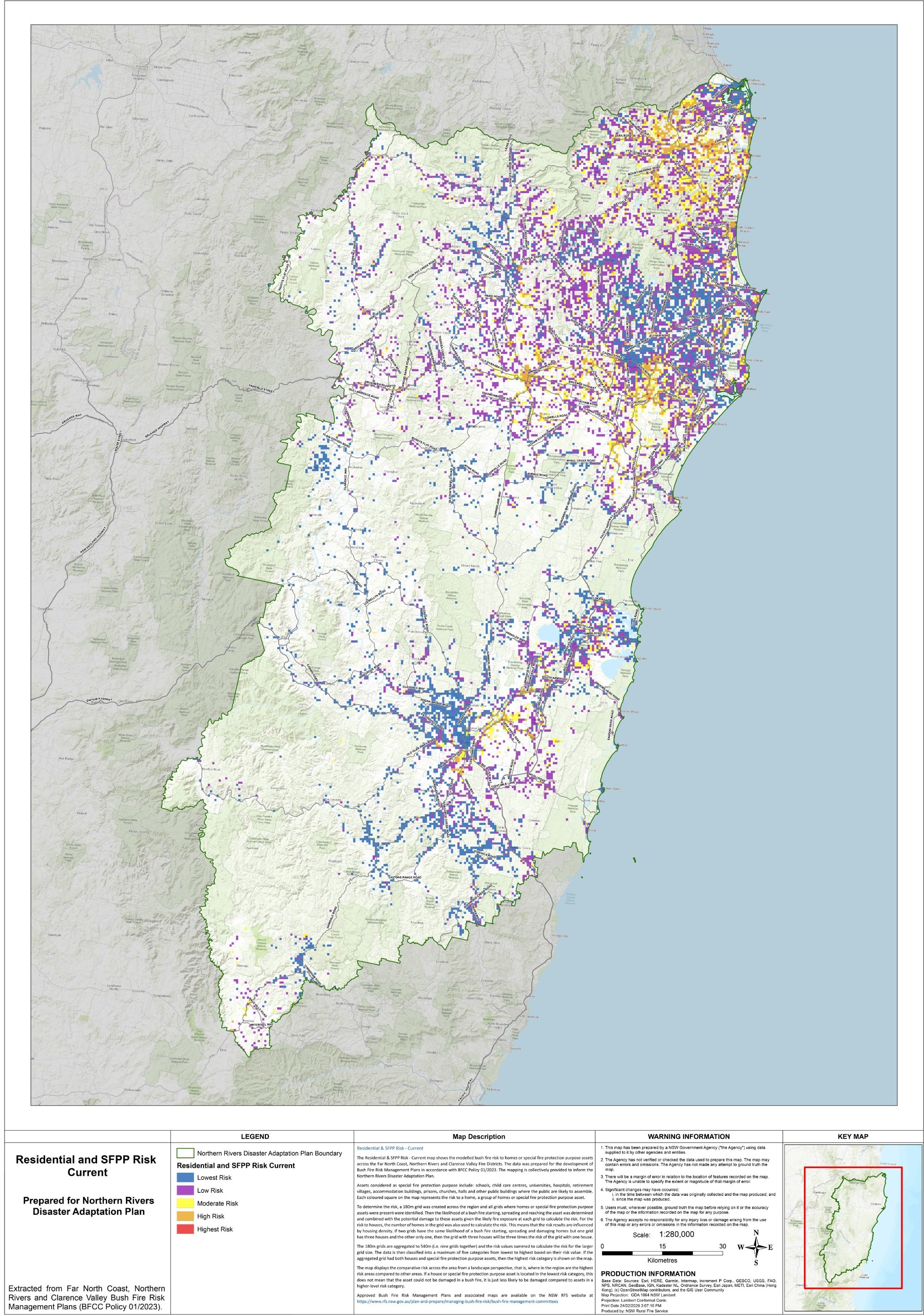
Maps prepared by the NSW Rural Fire Service as part of regional Bush Fire Risk Management Plans.
Current bush fire risk to the environment in the Northern Rivers
The map below indicates the current level of bush fire risk to the environment across the Northern Rivers.
The blue and purple show low risk areas, yellow shows moderate risk areas, and orange and red show high risk areas.
Areas where the environment is considered at higher risk are locations with threatened species, sensitive vegetation (e.g. rainforests) or land managed for conservation or environmental outcomes. Areas of highest risk include the Gondwana Rainforests of Australia World Heritage Area and areas with threatened species or ecological communities.
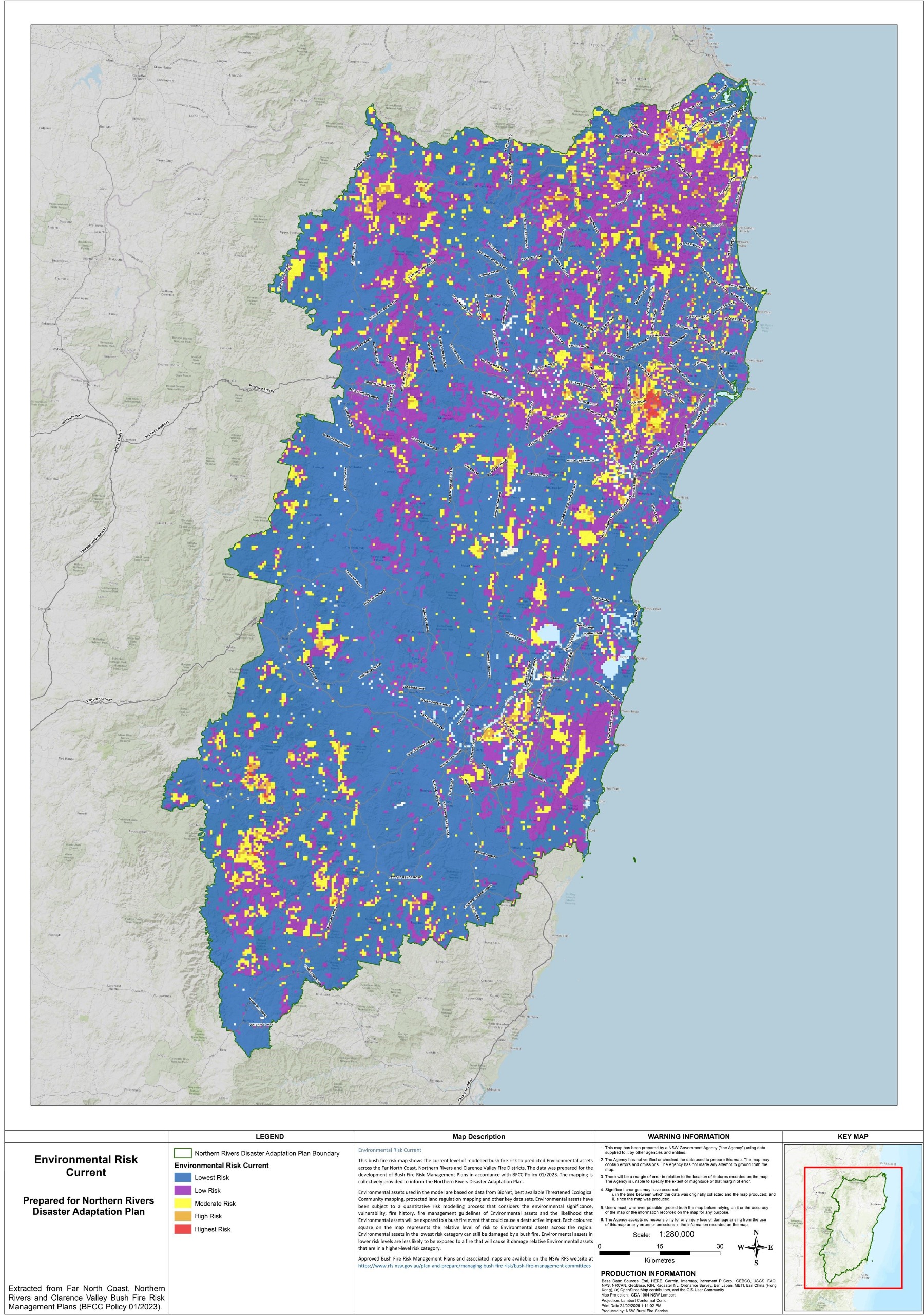
Maps prepared by the NSW Rural Fire Service as part of regional Bush Fire Risk Management Plans.
Future risk
- It is projected that by 2050 there will be an average increase of 0.2 severe fire weather days per annum, which would further rise to 0.8 days by 2090.
- Bushfires are likely to be affected by changes to rainfall, increasing average temperature and increasing number of hot days. This is expected to reduce the interval between fires, lengthen the bushfire season, increase fire intensity and shorten the window for safe fire management.
- The greatest increases in severe fire weather days are projected to occur in inland areas north of Grafton. Bushfire risk is also expected to increase due continued population growth.
Impacts
|
|
Built
|
|
|
Social
|
|
|
Economic
|
|
|
Natural
|
Next steps
Note: The information contained on these Have Your Say website pages is general information only, based on knowledge and understanding at the time of publication (June 2026) or otherwise based on data which pre-dates its publication, and may be subject to change at any time without notice. The State of NSW and its agencies (including the NSW Reconstruction Authority) do not give any warranty or representation as to the accuracy, reliability or completeness of the information. Read our full legal notice at bottom of the Have Your Say landing page.


